
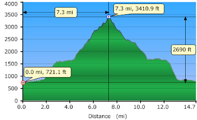
It appears that the road to Staircase FS-23 is going to stay open this winter. If memory serves me correctly, last year they closed it on November first. I planned to take it a bit easy on this hike after just recovering from the flu but this trail tricked me again. I thought it was going to be 12 miles RT but it was 14.71 according to my GPS(r).
Because the bridge over the river washed away, the trail now starts at the far end of the causeway; only homeowners get the key to the new bridge's gate. The trail follows a road and runs a gauntlet of no trespassing signs for 1.5 miles. After that the trail follows an old logging road with HUGE old growth stumps on each side for about 4 miles. I was surprised to find no trespassing signs past the forest service boundary. It looks like all of the Lake shore is private property, including the old public campsite. I was very tempted to give the Edward Abbey treatment to all of those ugly signs.
Both ends of this trail that once connected the North and South Fork Skokomish trail have been destroyed by logging, but the ridge in the middle is nice. This trail does not see much use as it does not lead to the high country, it is mostly logged and you now have to walk ½ of a mile just to get to the trail head. I worry that this trail will disappear if it does not get some TLC very soon. There were a lot of blow downs and the trail is muddy and overgrown in a few spots.
About a mile after crossing dry creek the logging scars disappear and you are on a lovely isolated little ridge. I hiked up the ridge campsite and had a little fire. Then I left my lunch near the fire coals to stay warm as I headed for what my GPS said was the top of the trail but the waypoint is wrong I’m not sure if I have yet been to the top of this trail. I’ll have to go back. I did go far enough to see the logging scars on the other end.

Walking across the causeway

These trees were cut before the river was damned to form Lake Cushman

The river level is low; the Skokomish tribe finally won and got the city of Tacoma to stop draining the South Fork dry every summer. See the way these logs have been placed?

Mount Rose and stumps. I think that is Dow Mountain in the background

Waterfall near the lake shore


Dog log fire

Logging roads and logging scars mark the entrance to the South Fork Skokomish Drainage
Then I went back to my fire to find that my lunch bowl had melted. Oh well, I had plenty of food. So I gave my lunch to my dog. I was rather manic at this point and I decided to stay by my little fire for so long that I knew I would be hiking out in the dark. It rained just a little bit on this hike but the weather was warmer than I expected.
The end of the trail is so ugly that there would be nothing to miss by hiking it in the dark and I had two sources of light with me. I decided to give myself just enough time to make it to the river crossing before dark.

1.5 hours before sunset and 7 miles from the trail head.
I hiked in the dark without my head lamp until about 50 minutes after sunset. Then I turned on my lamp for the rest of the hike out. In total I think I hiked for 3 miles in the dark.
I tried to do some night time photography like I did no my Ellinor Sunrise hike but it did not work out so well with my point and shoot on Mount Ellinor I had a fancy DSLR. This hike will be my last hike with my point and shoot. I ordered a fancy DSLR for myself a few days ago and it should be here in time for my next hike.


I want to know who Kristin Delaney is and why she died on this trail in 1986. Her cross is on the trail. Normally I am offended by memorials on trails but since this girl died right on this spot, I think it is ok for her memorial to be there. Her cross is broken now; it was not broken the last time I was up there. I found it upside down but I replaced in an upright position. I think her cross was broken on purpose. I may just go see if I can get a copy of her death certificate since Google is giving me no answers and I have been wondering about her death since I first saw her cross in 2005.
Here is what the cross looked like on my first trip of this trail in December of 2005


Patches sees water, Patches jumps in. Silly dog!

This mushroom smelled like a really sweet pastry

Same waterfall but after dark
I saw a few chanterelles and lot of russulas but not else of much interest mushroom wise. I did not pick anything.
I had complete solitude for the entire duration of my hike and I took full advantage of it.
14.71 miles
2,600 feet elevation gain
First hike in my new waterproof boots. Having dry feet was very nice!
Other times I have blogged this trail


One author says this stream crossing is dangerous. I disagree. This is the biggest I have ever seen dry creek and crossing was easy. These pictures are blurry because it was getting dark, but I still think this is a fun series.
 Nothing scary about this

Dog getting read to cross dry creek ahead of me

There She goes!

Made it to the first rock

Getting ready to launch of first rock

Having second thoughts

Going for it

Oh girl! This creek is pulling her down she may have to ford in a different spot.

Almost made it, she's a good strong swimmer

Just about there

I made it! What are YOU still doing over there?

Now we are both on the other side


4 comments:
I hiked this trail with the THEM group the next day (see WTA trip report by twopaddles for Nov. 3). I have hiked this trail a few times but never ventured over to the South Fork side. You are pretty venturesome. I found a little baggy with some moleskin in it. Looked fresh. Yours?
It might have been mine. I remember putting some together and putting it in my first aid kit for my Mount Adams attempt because I planned on wearing boots for that hike. Since I normally hike in shoes I never get blisters. You can keep it anyway. Thanks..
But if you find my bicycle I sure want that back!
My friend and I hiked Dry Creek Trail today (7/22/14) and found the broken memorial cross with Kristin Delaney's name on it. Did you ever find out how she died? I also could not find anything on Google except your blog entry.
All I have been able to learn is that she was 17, she had no external injuries and she was sent to the medical examiners office but the death certificate does not show the cuase of death. I think a real paper copy of the certificate might have all the info on it though. I just asked a clerk to look at her computer screen.. maybe all the info did not get tranferred to a computer?
Post a Comment