Wednesday, August 30, 2006

Fall Mushrooms on the Upper Big Quilcene!

How exciting, it's mushroom season again. We have not had our fall rains yet so I was not expecting to see these mushrooms today. These were all in a river drainage area that is moist from snow run off.

Today I hiked up to Marmot Pass on the Upper Big Quilcene trail. I went a bit beyond Marmot Pass and climbed up to a 6,700 foot peak. It's not the highest peak on Mount Buckhorn but there was a geocache there. The area was totally socked in by clouds with no view at all. What a shame after such a hike to not get to enjoy the view. I could see no reason to go to the highest peek other than to say I did it since there was no view today. I have been on the highest peak in the past and the view then was breathtaking.

I felt really dizzy weak on the way up and it took me 5 hours to go up but it only 2.5 hours to go down. I felt good at the end of the hike in spite of my troubles going up. My total time on the trail today was 8 hours. My elevation gain was 4,202 feet and mileage according to my GPS was 14.

Click on the pictures to make them bigger. My guesses as to what these are from Left to Right:
Scaly Chanterelle, A Russula?, a White colored Bolete with white spores, more russula, Chicken of the Woods, Young Lions , A strange looking polypore, Panther Amanita or maybe Amanita 
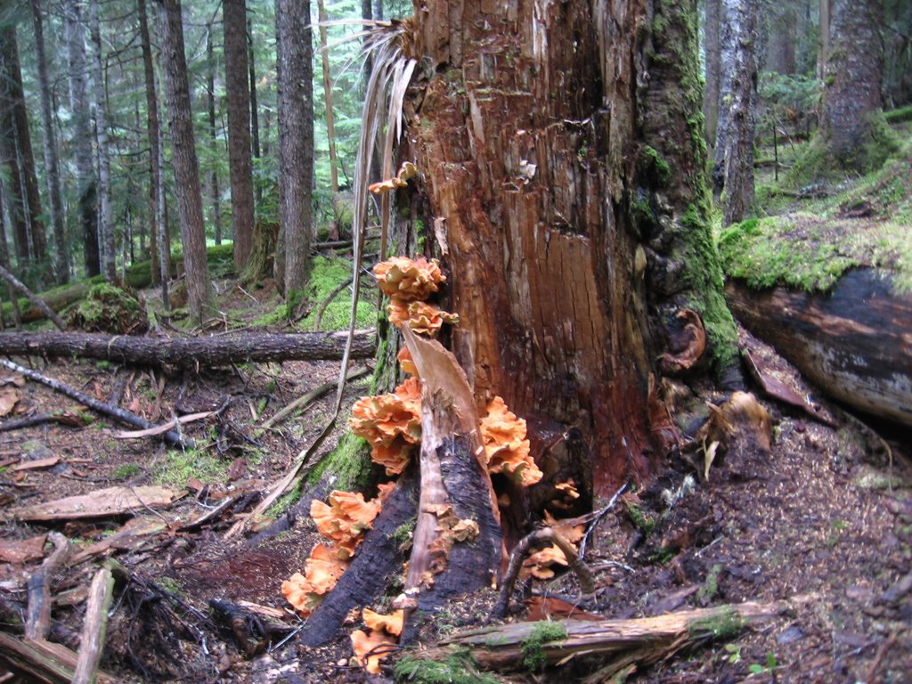
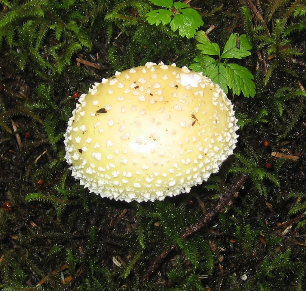
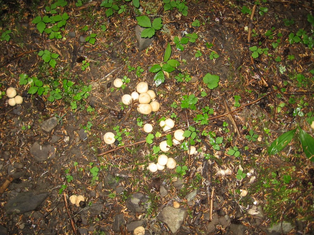
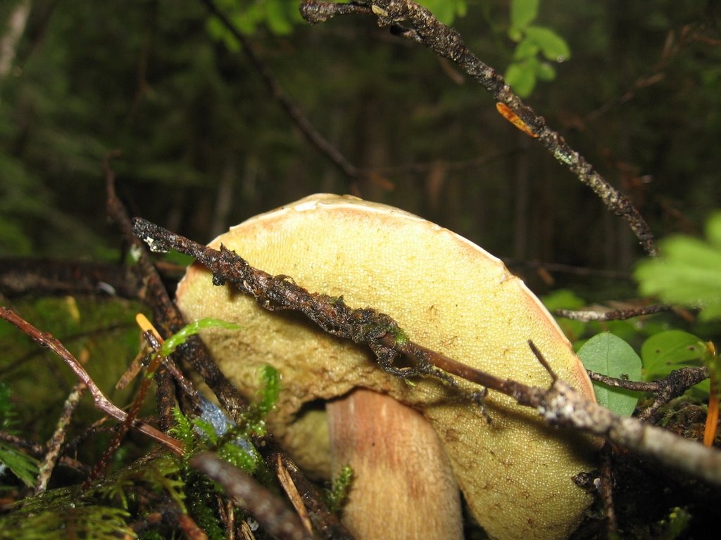
muscaria var. formosa, Puffballs, Underside of same White colored Bolete, close up of Chicken of the Woods undersides, A giant dead conk


Tuesday, August 29, 2006

Mount Rose Trail on Fire too

I get to go hiking tomorrow, it's been a while. My boil is finally gone and I can sit comfortably again. The fire on Mount Rose has crossed over the Mount Rose trail. I don't know if that is the trail in the picture to the left with the firemen or if that is a clearing that the firemen have made.

They are fighting fire with fire on Mount Rose the the picture to the left is a fire that was set by Firefighters.

Click on any of these images to enlarge them. The topo map below clearly shows that the fire has gone over the trail.


Saturday, August 26, 2006

I've got a Boil and Mount Rose is on Fire

It started right after our backpacking trip to the ocean and required a trip to the er to get it lanced. It was painful and horrible and a terrible way to end my summer. But I hope to be able to go hiking again soon. I had to get it packed three times but the final packing came out today. Now I can sit down without a huge amount of pain. I've never had a boil before and I sure don't ever want to have another one! My pharmacist has armed me with Keflex and Vicodin but I've not had to take a Vicodin for two days now. Hopefully the grogginess caused by the Vicodin will go away now.

In the meantime Mount Rose is still on fire and it is now 750 acres. But it looks like they finally have enough people and machinery in place to really start fighting the fire. You can see some of the smoke from this Hood Canal Webcam.

The Mount Rose trail has not been encroached by the fire but they are starting to mention fighting the fire from the East side of what they call "The Mount Rose Pathway". The fire started on the West side of the Mount Rose Trail if they are fighting it from the East Side of the trail that is not good news.

If you click on any of these pictures you will get to see a much larger image.

I don't know where I will hike next week. Clearly I will not be hiking any of the Staircase Area trails as they are all closed. Mount Elinor is open but in the smoke.

Perhaps I will do the Upper South Fork of the Skokomish Trail. There is just over one month left before car access to the trail head gets cut off until next spring.

The maple trees across from my front yard have started to change colors. I hate how maple trees are the first to announce that the end to summer is nearing. But at least this year I can look forward to the fall mushrooms and I know exactly where to look for them this season.

While convalescing from my boil I have kept entertained by reading the journals from folks who are currently through hiking the Pacific Crest Trail (PCT) and by tinkering around with home made alcohol burning stoves. It is my dream to through hike the PCT once my kids are a bit older. Perhaps I can try it as soon as the year 2010.

Sunday, August 13, 2006

More on the Mount Rose on Fire

Pictures of the fire on Mount Rose. Click on them to see larger images.


Friday, August 11, 2006

Rialto Beach Backpack

Back from "hiking" on Rialto beach. We went about 1.5 miles, to the other side of "Hole-in-the-Wall, and then pitched the tarp-tent on the beach just inches from the evenings high tide line. My husband was too exhausted to look for a more suitable spot after working an especially hard shift two days earlier.

We had fun staying up till high tide at 11:pm watching to see if we would have to move the tarp-tent. A drift log kept the sea off the tarp, it might have been hit by one wave if not for the drift log. We had to move our campfire twice as the ocean came in and put it out. The moon was full so we had plenty of light.

My husband said there were brown creatures the size of rabbits running through the woods the first night but I did not see them.

We bedded down for the night in the tarp with the kids in the middle. We had more food then would fit in the bear can, we kept the extra (all trail mix) by our heads. The idea being that animals would be afraid to come near us to steal the food.

I was woken up by a vole running across my arm, I let out a good scream and promptly went back to sleep after zipping the bug screen shut on my half of the tarp.

Rain woke us up at 10:00 am but the tarp kept us dry. I dressed the kids in their rain gear and kicked them out for the day. My husband had forgotten to pack any rain gear for himself, so we were not able to hike in the rain. I was at the peak of PMS and fighting a cold so I did not really mind just sitting around the campfire all day. My husband was able to stay dry by the campfire. It drizzled all day long.

I bought a MSR mini works water filter just for this trip. Normally I drink right out of the mountain streams and have never gotten ill. I do not trust the river water down at sea level though so in preparation for this trip I bought the first water filter I have ever owned.

My oldest daughter and I walked about 1.5 miles round trip to fetch water from Ellen creek. The creek flowed onto the beach but then went underground before it reached the surf. I walked up stream to a point were the flow was good and started filtering water. I was able to fill a wide mouth Nalgene bottle 4 times before I had to clean the filter element. I don't normally carry heavy Nalgene bottles but my filter was made to fit on a Nalgene bottle for the ease of two handed rather then three handed operation.


In the afternoon we moved the tarp to a campsite up in the woods since the high tide was predicted to be even higher.

Shortly after moving the tarp-tent I spotted a rabbit so the mystery of the brown creatures "running" through the woods seemed to have been solved.

While I was looking at the rabbit I observed some movement out of the corner of my eye. I turned to look as saw a skunk. SKUNK! My duagher and I both yelled. That frightened the skunk so it ran away, It was an adult skunk with several children and they all ran off and disappeared under our tarp tent.

OH NO! A whole family of skunks in our tarp-tent.. How to get them out?? We knew that we did not want to corner them in the tent. So we thought that opening the front wide and then banging on the back of the shelter might be the best plan to get the skunks out.

My husband opened the tarp-tent and shone his light in and could not see the skunks in the tent. It turned out they had only run under one end of the vestibule and out the other end.

We observed the skunk family several more times that evening. We had pitched our tent on their beach access trail.

Once again we stayed up to watch the tide roll in. We determined that the tarp-tent probably would have only been hit by one wave if we had left it in place.

The rain stopped and my family went to bed, but I could not sleep so I sat up under the full moon and watched the waves until about 4 am from the warmth of the fireside. A group of backpackers passed by in the night, they too were enjoying the full moon.

The next morning we got up at 7:00 and prepared to hike out on the low tide. My husband had an easier time hiking out then in because he had carried the food in and most of the food was gone now. My load was slightly lighter since I did not have any water to carry, but I did have some dirty diapers to carry.

My pack weighed 48 pounds with the baby (30 pounds) in it but she walked about a mile so for most of the "hike" my pack weighed 18 pounds but I still had to hold her hand and keep her out of the water and coax her along even when I was not carrying her. My husband's pack weight was 38 pounds and daughter's pack weight was 18 pounds.

My husband carried the food in a 1.5 pound bear can, the tarp-tent, my sleeping pad, diapers his clothes and sleeping bag and pad, stove fuel, the water filter, two pounds of GORP his head lamp, cigarettes and his toiletries.


My 9 year old carried her clothes, the baby clothes, her sleeping bag, her and the babie's sleeping pads, the babie's sleeping bag, two quarts of water, two pounds of GORP, her headlamps and two small toys.

I carried the baby, the first aid kit, three quarts of water, my clothes, my sleeping bag, my toiletries, two pounds of GORP and my head lamp.

We also all carried an ultra light cook set, each set weighed between 8 and 10 ounces and included a pop can stove, pot, windscreen, reflector and a spoon.

Our 42 ounce ultra light tarp-tent worked out well, we all stayed
warm and dry under it and surprisingly condensation was almost non-existant. I expected a fair amount of condensation to form under it since we were camping at the ocean in a steady drizzle.

On the way out My husband's pack was about 28 pounds, my 9-year-old's was 16 or so pounds and mine was about 46 pounds.

I have no pictures from the trip because I did not want the extra weight of the camera.

Thursday, August 10, 2006

Mount Rose on Fire


A fire has been burning on Mount rose since July 25th. Affected is the North Fork of the Skokomish trail that I hiked so many times last year along with the entire Staircase area.

I've been following the newsfeeds since late July and the fire just keeps growing. It is getting closer and closer to the Mount Rose Trail and is headed towards the National Park.

It has already been announced that the Staircase area will be closed for months after the fire is put out due to debris falling on the road.

The cause of the fire is human activity but no details have been released. It seems to have been started near a rock overlooking Lake Cushman that people jump off of in the summer.

http://www.inciweb.org/incident/363/:

Summary

Thursday 08/10/06

The 400-acre Bear Gulch #2 fire, 15 miles northwest of Hoodsport, continues to burn on the southern slopes of Mt. Rose. Due to falling debris, Forest Road 24 remains closed to all traffic, closing access to the Staircase area of Olympic National Park.

The fire is smoldering and creeping through the dry undergrowth; flame height is less than one foot, gaining only a few acres each day. The steep, rocky surface of Mt. Rose prevents installation of fire line. Two helicopters douse hot spots along the perimeter with water from Lake Cushman. Recent cool temperatures and light morning showers help slow the fire.

The area beneath the fire is extremely hazardous. A high potential for future deposition remains. An assessment team is in the area to evaluate hazards on the slopes above FS Road 24. The area is closed to all types of traffic including foot, stock, mechanical and motorized (including boats) and people should not attempt to enter the area. A temporary gate has been installed on FS Road 24 where the pavement ends and is staffed by security personnel.

In addition to the closed access to the Staircase facilities, the North Fork Skokomish River, Wagon Wheel and Staircase Rapids Trails are also closed in the park. The Mt. Rose and Dry Creek Trails are closed in the adjacent National Forest. While these closures are necessary for a limited area and include a portion of the lake due to helicopter operations, most of the Lake Cushman area is available for recreation as usual. Mt. Ellinor and Mt. Washington areas continue to be open to recreational opportunities.

Campfire and smoking restrictions are currently in effect. Campfires on the Olympic National Forest are only allowed in designated campgrounds in the fireplaces provided. No fires are allowed in the backcountry, wilderness areas or in any dispersed sites. The Forest also has restricted smoking to developed recreation sites as listed above, within vehicles or on cleared areas of forest development roads only. In Olympic National Park, campfires are permitted only in established fire grates in developed campgrounds. Smoking is only permitted within vehicles and areas clear of vegetation. Backpacking stoves are allowed in wilderness areas. Other county and local restrictions also apply.

A Type III local interagency management team from the Olympic NF, Olympic NP and WA DNR (IC VanBuskirk) has taken over the management of the fire. The nearby Skokomish Indian Tribe is providing boat patrol of Lake Cushman to facilitate helicopter operations.

Saturday, August 5, 2006

High Divide Loop


Last week our family decided to camp at Sol Duc Hot Springs. We decided this place would have some thing for everyone. A pool for my kids and my husband to play in and hiking trails for me. Since my Husband does not hike he watches the kids for me while I hike. It's always nice if the trail head happens to be near a great visitor center with a view (like Hurricane Ridge last week) or near a pool.

I had some dragons to slay at Sol Duc, I had stayed there twice in the past. The first time it was with some dysfunctional relatives and at one point they all stopped speaking to me. There was a lot of bickering and it was not the nicest experience or the most relaxing camping trip I had been on. The swimming was horrible too, the big pool was ice cold and I could not stand to swim in it. I grew up swimming in the Tahuya river so if a pool is too cold for me to swim in it's REALLY cold! The small pool was only luke warm and it was filthy.

The second time I stayed at Sol Duc it was in the dead of winter, my 5 or 6 year old (at the time) daughter and I had the entire campground to ourselves, well almost. We did have to share with a big elk that was always hanging around the bathroom. This would have been a good trip except for the fact that when I tried to leave the campground to go home the transmission in my van broke down. After a few minutes of trying I was able to get the van into drive (I always drove in overdrive) and limp it all the way home to Port Orchard. Sol Duc would have been an awful place to need to get a tow from. It cost me $1,600 for a new rebuilt transmission in that old van and the new transmission only lasted about 25,000 miles before it started acting up again. Back then pretty much every vacation ended with the Van breaking down.

So those were my memories of Sol Duc. I needed to stay and Sol Duc again so I could have some happy memories of the place instead of always thinking about horrible stuff as I drove past the turn of to Sol Duc on 101.

We pulled into the Sol Duc campground and found a suitable campspot on Loop B. My husband was not happy to be so "far" from the lodge and there was some tension about that. As a hiker I did not consider the 1/4 to 1/2 mile walk to the lodge to be an issue at all. But he did have the kids to think of too.

The first thing I did after parking up was walk down to the Ranger Station to try to get some information on local hikes. I was thinking about doing a 20 mile loop that would take me past the spot where I was airlifted when I was 9 weeks pregnant and give me a chance to slay yet another dragon. But I did not know if I was up to the challenge of hiking 20 miles so I was also thinking about an alternate 15 mile loop. I had all kinds of questions for the ranger but the ranger station was not staffed. All I found there was some maps just like the ones I have at home and a box to put your money in.

Then I noticed something that would change everything. There was a sticky note on the wall that said the "Monday Hikers" were staying on my loop in sites 59, 60 and 61. I had hiked with them once before and they hiked too fast for me to keep up but I decided to go talk to them anyway.

I walked back to the campground and told my husband that the Monday Hikers were staying on our loop. His answer was " We just can't get away from them can we?"

We had a good chuckle about that because when we stayed on the Duckabush this winter the Monday Hikers were also there. Our paths seemed to cross often.

With some trepidation I decided to go see what the hikers were up to. As I approached the campsites they were supposed to be in I noticed two women who looked like they might be hikers. I overheard one of them saying the word "trailhead" so I asked if they were with the Monday Hikers. Yes they were! Like like me were trying to find the rest of the Monday Hikers but they had not seen the note on the board. The two women were Linda and Laura, I asked them where the hikers were going and they told me they were doing the 20 mile loop that I had been thinking about doing and they hiked a bit slower then some of the others. That settled it, I decide to hike with them.

I met up with Linda and Laura at 7 am, they were kind enough to give me a ride to the trail head. At the trail head we met up with Shar. We also saw the rest of the group was there but they left without saying a word to us. I knew we would not be seeing them again and frankly I was relieved that I would not have to try to keep up with them. So it was Linda, Laura, Shar and I who hiked together but after we reached Deer lake Jack and his wife Faith caught up with us and we leapfrogged with them for the first 12 miles or so.

The high divide is just as beautiful as I remember it being. I am posting pictures of my previous high divide hike on this blog. Laura took lots of pictures for me but it turns out that the email address I gave her is bad. I think the domain is actually gone or the server is down. I hope I can find another way to get a hold of her because she took pictures of the place I was airlifted from and I want my husband to see them.

I had been on a solo backpacking trip, I started out at Olympic Hot Springs, went over Appleton Pass and was going to do the high divide loop then return to Olympic Hot Springs when things went terribly wrong:


Peninsula Daily News July 25 2003

Woman Airlifted
Olympic National Park

- A U.S. Coast Guard helicopter airlifted a pregnant woman Tuesday night from Olympic National Park when the 40 year-old woman began hemorrhaging, the Coast Guard Reported.
First Name Last Name, whose hometown was not reported was evacuated from a field near Bogachiel Peak, just south of Seven Lakes Basin, after the Coast Guard received a call from park rangers at about 8:30 p.m.

A medical doctor hiking in the woman's group recommended an immediate evacuation, the Coast Guard reported. The HH-65 Dolphin helicopter landed in the field, at an elevation of 5,000 feet, retrieved Vetter and transported her to Group/Air station Port Angeles, where medics from the Port Angeles Fire Department met the craft and took (my last name)  to Olympic Memorial Hospital, according to the Coast Guard.

The hospital has no record of
Last Name and her condition was not available.

They added several years to my age!
----


We took our lunch at Bogachiel Peak and enjoyed the views while wondering what the next ten miles had in store for us. I felt good for having just hiked ten miles but I knew I was not going to feel good after hiking another ten. After we left the peak I broke out ahead of the group so I could spend a few minutes alone at the spot I had been airlifted from. It was good to see that spot again and to lay a few ghosts to rest.

---
Peninsula Daily News July 27 2003

Airlifted Pregnant Woman OK Port Orchard

-- A
pregnant woman who was airlifted from Olympic National Park last week is fine, and so is her unborn child.

First Name Last Name 36, of Port Orford, was evacuated in a U.S. Coast Guard helicopter from High Divide at an elevation of about 5,000 feet, Tuesday evening when she began bleeding.

Last Name's last name and age were incorrectly reported in a story in Friday's Peninsula Daily News.

Last Name who is eight weeks pregnant, was checked by staff at Olympic Memorial Hospital and said Friday she and the unborn child are fine.

Last Name, a seasoned hiker, was four days into a back-country trek and was hiking alone when she reached her campsite Tuesday night and began bleeding.

"I thought I was having a miscarriage," she said.

Other hikers staying at the campground went down the trail and contacted the Park Service for help,
while a doctor on the trail assisted her and recommended she be evacuated, she said.

She does not know who the doctor was, she said.


"I'd like to thank that doctor and everyone who helped me," Last Name said.

---

After leaving the peak we hike along the ridge of the high divide, past my airlift spot and then down to heart lake. We took our last long break at Heart Lake. Jack, Faith and Shar caught up to us at Heart lake but we left them there and did not see them again on the trail. I wanted to swim in Heart Lake but it was not as warm as I remember.

From our vantage point at Heart Lake we saw not one but two bears up on the hillside. So once again I SAW A BEAR! But it was not as exciting as on my last hike since these bears were so far away. We also saw some elk on the hill side.

After leaving Heart Lake the trail drops down through Sol Duc park and then into the gloom of the virgin forest along the banks of the Sol Duc river. Down in the gloomy forest we passed a man who told us that we only had 4 miles left to go.

Laura liked the sound of that and she took the lead and we started hiking much faster. But the man was wrong. We really had 5 or more miles left to go. The last 3 miles were the longest and we were more then ready to get finish our hike and go soak in the hot springs.

11 hours after we started our hike we made it back out to the trail head. Congratulations and high fives all around and off to the hot springs for a much deserved soak.

It was good for me to go back and complete this loop and I feel proud to have done a 20 mile day hike. My previous mileage record was 19 miles but that was several years ago.

But then again it looks like this was not a 20 mile hike. Day Hike! by Searbury Blair, Jr. states that this hike is 18.8 miles round trip with 3,500 elevation gain. Interestingly this book gives the trail description going counter-clock-wise (the direction we went) while most other guides give the description clock-wise.

This hike was a whopping 26 on the hike difficulty calculator.

I really enjoyed hiking with Laura and Linda with their company the miles seemed fly by.

Now when I drive by Sol Duc I will have happy memories to think of.