Showing posts with label North Olympics. Show all posts
Showing posts with label North Olympics. Show all posts
Sunday, September 15, 2024


Friday, July 25, 2014
Coming full circle on the high divide -day 5 the primitive trail

Day 5 Olympic Hot Springs to Barnes Creek
13 miles (I don't care what the map said, it was 13 miles dammit!) with 3,000 feet elevation gain and 3,500 feet of elevation loss
We got up early and hit the trail at 6am. I still had a touch of the migraine from the night before, the nausea was gone but I had a mild headache so I took one of my migraine pills, figuring just one would do it.
We had a long day ahead of us. We had to leave a day early so we would not run out of food, so instead of doing just 3 miles to Boulder Lake we needed to go about 13 miles to Lake Crescent to position ourselves to take the bus back home the next day. My goal was to get within one mile of the bus stop.
We had a long day ahead of us. We had to leave a day early so we would not run out of food, so instead of doing just 3 miles to Boulder Lake we needed to go about 13 miles to Lake Crescent to position ourselves to take the bus back home the next day. My goal was to get within one mile of the bus stop.
My daughter was not a happy hiker as we headed up and out of
Olympic Hot springs. She went on strike; she kept sitting down and
saying there was no way she could do the hike all the way out today. I did not know what was going to happen, we
were fresh from resting up the day before and should have been strong and ready
for this hike, but my daughter was not going to make it at this rate. What was I going to do? Staying at Boulder Lake was not an option, we just did not have a enough food for that. We had to get out, but how? How could we ever hike out with my daughter flopping herself down and the trail over and over and refusing to budge after just 1/4 of a mile?
 |
| Boulder Lake |
I would let her have the last of the food and I would go hungry. My daughter cheered up; soon she was rushing down the trail ahead of me and singing and I could barely even keep up with her.
Then something I was hoping for happened. My daughter came around; she said she thought we should take a break at Boulder Lake so she could look for frogs and then we should try to hike out. I said that I thought that was a good idea. With the idea of hiking all the way out now her idea instead of my idea, she was happy to do it. Wow, what a difference. That little bit of psychology saved the day.
 |
| Boulder lake |
By the time we got to the lake my migraine was gone.
 |
| Brook Trout |
 |
| Brook Trout |
We left Boulder Lake and headed up the trail that said “Happy
Lake”. That was the only sign and we
were not going to Happy Lake, but I knew that we would be on the Happy Lake
trail for a bit. Another sign mentioning Aurora ridge or Lake Crescent would have been comforting.
Soon we were climbing up into lovely meadows and ridges covered with wild flowers. We were still in a cloud and everything was wet and cold and misty. I had been warned that this trail was hot and dry, so I was glad for the clouds and I dumped out more of my water. Now we had three and a half liters of water between us and even that was more than we needed.
Soon we were climbing up into lovely meadows and ridges covered with wild flowers. We were still in a cloud and everything was wet and cold and misty. I had been warned that this trail was hot and dry, so I was glad for the clouds and I dumped out more of my water. Now we had three and a half liters of water between us and even that was more than we needed.
I was very worried about what laid ahead on the Barnes Creek
Primitive trail. Would we really have to
drop 4,000 feet down on a short primitive trail? How was I going to do that without killing my
knees? Would we lose the trail again? Oh anxiety, my constant companion, I wish I
could shake it off. I convinced myself
that we would drop some of the elevation on the ridge trail. But every time the ridge trail went down, it
went right back up again.
It was a beautiful ridge, wild flowers were everywhere and the cloudy weather made the colors more vibrant. But I kept waiting until later to take pictures of them, I was too anxious about the next segment of our hike. I never did get any good pictures of the flowers on the narrow ridge trail.
It was a beautiful ridge, wild flowers were everywhere and the cloudy weather made the colors more vibrant. But I kept waiting until later to take pictures of them, I was too anxious about the next segment of our hike. I never did get any good pictures of the flowers on the narrow ridge trail.
 |
Soon we reached the junction of the Happy Lake Ridge trail and the
Aurora Ridge trail. We turned left to
follow Aurora Ridge. The trail was in
good shape and flowers were everywhere. In
a couple of places we could not see the trail under our feet but could clearly
see it just a few feet ahead of us.
Someone has done a good job of laying branches over the side paths to
keep people from accidentally leaving the trail too.
 |
| Happy Ridge and Aurora Ridge Junction |
There was much hilarity and silliness as we traversed the
ridge. I was anxious but my daughter was
happy go lucky as usual. I released my anxiety with silliness. Screeching whenever the trail went up hill
that I couldn’t do it and condemning the trail for not letting me hike downhill. Why wouldn’t the trail let me hike downhill? That was fun.
 |
| slightly confusing junction of Aurora Ridge and Aurora Divide trails |
 |
| Tiger Lilly |
I knew that I needed to turn right here onto the Barnes Creek trail but the sign made no mention of the Barnes Creek trail, it said Aurora Divide trail and Aurora Ridge trail, the sign also said it was 7.2 miles to Lake Crescent on the right and 15 miles Sol Duck straight ahead. The arrow pointing to the Aurora divide trail was missing as the corner of the sign had rotted away. Also the sign was leaning on a tree, so no way to know if any of the arrows were pointing in the right direction.
We turned right, but my GPS said I was on the wrong track, it said I was on the Aurora Divide trail. This was confusing. I knew I need to turn right and go down to the lake, but I thought I was supposed to be on the Barnes Creek trail. I double and triple checked and was never satisfied that I was on the right trail; all I knew for sure is that we were headed for Lake Crescent and that was all that really mattered. The actual name of the trail did not matter as much as the destination.
 |
| Small landslide on Aurora Divide trail |
 |
| Tarn at the start of Aurora Divide Trail |
So we headed down the primitive trail not even knowing the
trail name. After about a quarter of a mile I exclaimed to my daughter that this was the most civilized “primitive” trail that I had ever seen. It was nice and clear
and it had wonderful tight switchbacks that snaked down, down and down. Perhaps primitive trail means something different in the park than it means in the forest?
I kept expecting the trail to turn primitive, I kept expecting to lose the trail, but we never lost the trail. All that happened was that we got very tired, but we kept on going until we got to the junction with the Lower Barnes Creek Trail.
I looked at the sign that pointed at the trail we had come down and it said Aurora Divide Trail. Okay, so there was never any need to worry about a primitive trail, it was just that both of my GPS maps at home pegged this trail as the “Barnes Creek Primitive Trail” when it really was the Aurora Divide extremely civilized trail. My guidebooks that I studied at home did not make the situation any clearer; it just seems to be a confusing area when it comes to the actual names of the trails.
I kept expecting the trail to turn primitive, I kept expecting to lose the trail, but we never lost the trail. All that happened was that we got very tired, but we kept on going until we got to the junction with the Lower Barnes Creek Trail.
I looked at the sign that pointed at the trail we had come down and it said Aurora Divide Trail. Okay, so there was never any need to worry about a primitive trail, it was just that both of my GPS maps at home pegged this trail as the “Barnes Creek Primitive Trail” when it really was the Aurora Divide extremely civilized trail. My guidebooks that I studied at home did not make the situation any clearer; it just seems to be a confusing area when it comes to the actual names of the trails.
 |
| Ah, so we were on the Aurora Divide Trail all this time |
 |
| One what?? |
By this time we were very tired and the trail was longer than expected. My left knee and ankle took a pounding dropping down 3,500 feet on the Aurora Divide trail in spite of all the wonderful switchbacks, I would be limping soon at this rate.
I was ready to quit for the night, but my daughter wanted to keep going and she was not happy when I made the decision to camp at the most beautiful campsite in the history of entire world, ever. The camp site was three miles up the Barnes Creek Trail. It was beautiful because I was so tired and so ready to stop for the night. It was also beautiful because it had logs to sit on, a river to get water out of and a fire pit with a stack of fire wood next to it. I did not even care that it was in a creepy little ravine.
 |
| Our last camp |
My daughter was mad that I stopped so she sat on the hill one switchback above the campsite and refused to come down as I fumbled around exhausted setting up camp. I nearly pitched my tent
inside out then I lit a fire and started cooking dinner. We had been wet and cold all day, the fire
was very welcome. It felt great to dry out my boots and walk around in bare feet.
My daughter was being stubborn, she got out her sleeping bag and set it up on the switchback and then she started filtering water and doing everything else she could think up to make it clear that she was setting up camp on the switchback. I knew she would come around before it got dark, so I ignored her carry on, but told her she was welcome to join me by the campfire at any time.
She was tired too, she accidentally dropped both of her boots and her water bottle down the hill. Then I watched in silent horror as her sleeping bag in its stuff sack began to roll down the hill and stopped just short of falling in the creek.
I continued to dry out my socks and my boots and to eat dinner while she stayed up on the hillside. She eventually gathered her stuff together and came down and finished off my dinner.
I collapsed into my sleeping bag at about 7pm but I had to get up and walk around some because my legs had started to cramp up.
We had to hike three miles down to highway 101 to catch our bus at 10:20 the next morning so we both went to bed early.
My daughter was being stubborn, she got out her sleeping bag and set it up on the switchback and then she started filtering water and doing everything else she could think up to make it clear that she was setting up camp on the switchback. I knew she would come around before it got dark, so I ignored her carry on, but told her she was welcome to join me by the campfire at any time.
She was tired too, she accidentally dropped both of her boots and her water bottle down the hill. Then I watched in silent horror as her sleeping bag in its stuff sack began to roll down the hill and stopped just short of falling in the creek.
I continued to dry out my socks and my boots and to eat dinner while she stayed up on the hillside. She eventually gathered her stuff together and came down and finished off my dinner.
I collapsed into my sleeping bag at about 7pm but I had to get up and walk around some because my legs had started to cramp up.
We had to hike three miles down to highway 101 to catch our bus at 10:20 the next morning so we both went to bed early.
Thursday, July 24, 2014
Coming full circle on the high divide -day 4 Rest
 |
Today was a day to rest and relax in the hot springs. We
explored the old car campground and the hot spring pools, we rested, we soaked,
and we ate two dinners. I put mole skin on my blister and gave it time to heal. I tried to relax but could not; PMS was rearing its
ugly head.
Some sort of science project is happening in the old car campground, there were little red flags everywhere. I used flags like that when I studied moss.
At about 1pm a couple arrived at the springs, they had hiked
in from Sol Duc spending one night at Appleton Crossing Camp. They told me
about the man they saw who had hiked from Olympic Hot Springs to Appleton
pass the day before. He said he had camped alone on Appleton pass. How strange that we never saw that man. We must have
crossed paths when we were off trail thrashing in the brush.
I was worried about my hike out on what all of my maps call the
"Upper Barnes Creek Primitive Trail". I knew we had to drop about
4,000 feet on that trail and was worried about dropping so much on a primitive
trail.
The man in the party confirmed that the trail would be as bad as the Mildred Lakes trail and it was hard to follow in places. This had me worried for no reason; knowing what I know now, I'm pretty sure that man had either never seen the Mildred Lakes trail or we were talking about two different trails called Barnes Creek.
The man in the party confirmed that the trail would be as bad as the Mildred Lakes trail and it was hard to follow in places. This had me worried for no reason; knowing what I know now, I'm pretty sure that man had either never seen the Mildred Lakes trail or we were talking about two different trails called Barnes Creek.
The pools are mostly filled in with yucky mucky cyano bacteria, they look gross but ironically they are probably more hygienic then ever with the road to the trailhead closed. I spent a good deal of time cleaning the muck out of the one pool that is below the trail since we were camped right above it. Scientists think that life on earth started in mucky warm pools like these.
My daughter was hungry all day, but we got to have two
dinners since we had skipped dinner the night before. Our second dinner of the day gave me a migraine. I guess there was just a little bit too much "natural flavoring" in that soup.
I inventoried the food
situation and it was not good. We were scheduled to spend two more nights in
the Olympics, one at Boulder Lake and one near Lake Crescent. We had enough
dinners left but we were down to just 12 tortillas, Coffee, sugar, some Nido and three bags of M&M's to eat for both lunch and
breakfast for two people for two days. We had just enough peanut butter and Nutella to spread on the 12 remaining tortillas. This was not going to work.
I decided that we would have to skip Boulder Lake and head out the next day. If we skipped Boulder Lake we could eat all we wanted to for the rest of the trip, but if we stayed at Boulder Lake one of us would have to go without eating.
My daughter does not have an ounce of fat on her but I have plenty of fat reserves, so it would be me who would have to go hungry. But I was in the throes of PMS, my hungry time of the month. I was dreading hiking without food and did not think my mental state would be a safe one for hiking if I had to go 48 hours with very little food.
I decided that we would have to skip Boulder Lake and head out the next day. If we skipped Boulder Lake we could eat all we wanted to for the rest of the trip, but if we stayed at Boulder Lake one of us would have to go without eating.
My daughter does not have an ounce of fat on her but I have plenty of fat reserves, so it would be me who would have to go hungry. But I was in the throes of PMS, my hungry time of the month. I was dreading hiking without food and did not think my mental state would be a safe one for hiking if I had to go 48 hours with very little food.
At seven I went to bed with a headache and an upset stomach from our second dinner. But at least my legs did not hurt after soaking in the pools and taking a day off of hiking. Every night of the trip my legs had cramped up and twitched and kept me awake due to my periodic limb movement disorder / restless leg syndrome. On this night my legs felt great.


 |
| Bridge over Boulder River is getting dangerous one plank is about the fall into the river |
 |
| Bridge over Boulder River |
 |
| Boulder river from the bridge |
 |
| They want you to walk here in the old logged over car campground |
 |
| Free living cyanobacteria in the pools |
 |
| Free living cyanobacteria in the pools |
 |
| Free living cyano bacteria in the pools they think life on earth started like this |

 |
| Pooooooooop |
 |
| Science project in the car campground |

 |
| Trail / Road to the hotsprings |
 |
| The upper super hot pool. The pipe for regulating the temperature was gone and the pool was very difficult to reach due to fallen trees |
 |
| Whoops.. did not see this sign until it was too late |
Wednesday, July 23, 2014
Coming Full Circle on the High Divide -Day 2 Airlift

Day Two: Deer Lake to Appleton Pass JCT campsite
9 miles 1,800 feet elevation gain
9 miles 1,800 feet elevation gain
We got up at about 7:30 and started hiking out of mosquito
hell at 8am. I yelled “Goodbye Mosquito
Lake” as we left. I hope I did not wake
anyone up. After leaving Mosquito (Deer)
Lake the trail climbs to more open country, the trail climbed past a couple of
beautiful tarns and then up towards the spine of the high divide. My daughter hiked strong on this day. Maybe the motivation of knowing that today
was the day I would show here where we were airlifted is what got her
going. She hiked without a complaint.
Just before we reached the top of the ridge near Bogachiel peak a man came up behind us and asked where we were going. I have him vague answers until I realized that he was a ranger. He was a very friendly ranger whose name I did not catch. He asked to see my wilderness camping permit and he volunteered water information for our hike up Appleton pass. He said there was only one sketchy section of snow on the entire hike and he was on his way up to cut steps into it because people were going the wrong way. We could not ask for better timing on this for us.
 |
| Tarn above Deer Lake |
 |
| Twisted trees above Deer Lake |
Just before we reached the top of the ridge near Bogachiel peak a man came up behind us and asked where we were going. I have him vague answers until I realized that he was a ranger. He was a very friendly ranger whose name I did not catch. He asked to see my wilderness camping permit and he volunteered water information for our hike up Appleton pass. He said there was only one sketchy section of snow on the entire hike and he was on his way up to cut steps into it because people were going the wrong way. We could not ask for better timing on this for us.
He passed us up and by the time we reached the snow he was
there beginning to work. He showed us
the correct way so we were able to stay on the trail and avoid following the
foot prints on the really sketchy off trail ridge that everyone had been taking. It felt good to have a ranger in sight as we
crossed the 10-20 feet of slightly sketchy snow. I taught my daughter how to kick steps into
the snow and showed her how far she would fall if she slipped so she would be
sure to kick in good steps. She just
walked in my footsteps.
 |
| 7 lakes basin |
After leaving the highpoint of the hike I began to look for
the campsite that we had been airlifted from when I was 8 weeks pregnant.
It took a while to reach it; it was further down that I had remembered.
The campsite was called Silver Snag, but there used two be to camp sites there. One campsite has been closed and one has been left open. It was the closed site that I almost stayed in the night I got airlifted. On this day I showed my daughter the log I sat on while I was waiting for our helicopter and took pictures of both of us sitting on the log.
The campsite was called Silver Snag, but there used two be to camp sites there. One campsite has been closed and one has been left open. It was the closed site that I almost stayed in the night I got airlifted. On this day I showed my daughter the log I sat on while I was waiting for our helicopter and took pictures of both of us sitting on the log.
 |
| Above Deer Lake 7 lakes basin junction |
 |
| Climbing |
 |
| Sound of music stuff |
 |
| Why lakes |
 |
| A little bit of snow on the trail |
Next we followed the ridge up and down until the drop off
for heart Lake. It was hot on the ridge
and we were starting to drag. When my daughter
saw Heart Lake she made a beeline for it right down the slope on the top of the
snow. I followed the actual trail down
to the lake, so it took me quite a bit longer to reach the lake than it took
her. The wind was blowing at Heart Lake
so there were no mosquitoes but the air was a bit cold. I swam across the lake a couple of times and
treaded water in the middle. I spent
more time in the lake that I should of and I got pretty cold, but it was so worth
it. My daughter just took one quick swim and
spent the rest of the time looking at frogs.

 |
| Heart Lake |
 |
| Heart Lake |
 After we left Heart Lake it was time to drop down to Sol Duc
Park. A bridge across a creek had washed
out there, so I went upstream to find a place to boulder hop across, then I could
not find the official trail because the trail where the bridge had been confused
me.
After we left Heart Lake it was time to drop down to Sol Duc
Park. A bridge across a creek had washed
out there, so I went upstream to find a place to boulder hop across, then I could
not find the official trail because the trail where the bridge had been confused
me. I was not at all lost, I was actually in the campground but I did not want to be caught trampling on vegetation. Suddenly a volunteer ranger appeared and I asked him where the proper trail tread was and he pointed it out to me. He was very friendly, he did not ask to see my permit but I think he might have asked if we were camping there at Sol Duc Park. I told him we were staying at Appleton Crossing and he repeated the same words the first ranger said “that’s a lot of miles”. Hmmmm that got me thinking and made me worry a little bit.
 |
| Our home for the night |
Appleton pass JTC camp was nice, we arrived just before
sunset, dinner was Ramen with the MSG flavoring packets tossed in the garbage, but with my home dehydrated hamburger and dried veggies added to
it. There were very few mosquitoes so I opted to not pitch the tarp and we slept well under the
giant trees.
We went to bed at about 9pm, we did not have a campfire that
night even though we could have. I like campfires, but the smoke
stuffs me up, so I tend not to light very many fires.
 |
| sleeping under the trees |
Tuesday, July 22, 2014
Coming Full Circle on the High Divide -Day 1 Bus trips and Mosquito hell
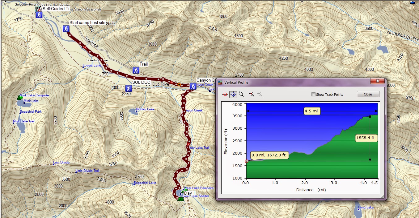
I’ve decided to split this blog post up into days to make it more manageable. On this 5 day trip we started at Sol Duc and finished at Barnes Creek.
Day one Sol Duc camp host site to Deer Lake
4.5 miles 1,850 feet elevation gain
My alarm went off at 7am so I got up and made coffee for myself and my spouse. My and my daughter's ULA packs were all ready packed for the trip with food and gear for 5 days plus we had a grocery sack full of food for the trip up.
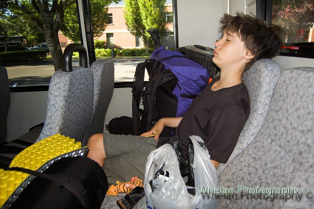 |
| Mason Transit 8:05 am |
My spouse is in very poor health and we were sad to leave him behind at home.
At 9:15
we made the seamless transfer to Jefferson Transit #1 to the Port Townsend Park
and ride. We had a one hour layover in
Port Townsend so we checked our packs with the visitor center and headed over to nearby
Kai Tai Nature Park where we ate lunch and I found three geocaches.
 |
| Kai Tai Nature Park Port Townsend |
Next we caught the Jefferson Transit #8 bus to Sequim, we did not have to
pay for this ride because we had day passes but on the way back we were charged
an extra dollar for this out of county route.
Next we had a 15 minute layover in Sequim and there were teenagers
playing loud music through headphones at the tiny transit center. Most
of the adults moved to the corner to get away from the teens who were smoking “pot
oil”.
 |
| Sequim Transit Center 15 minute layover |
Sequim is getting
a new civic center and there was construction everywhere. We were able to find an unlocked door so we
could use the bathroom at the transit center.
 |
| Port Angeles Famer's Market |
Next we caught the Clallam transit bus #30 to Port Angeles. On the
ride from Sequim the same teen sat in the back with headphones so loud that the
bus driver stopped and got up and made him turn his music down. There was a couple from California on the bus
who were taking a carless vacation and they seemed to be enjoying it.
In Port Angeles
we had about a 45 minute layover so we checked out the farmers market and Dairy
Queen where I was charged $2.05 for a medium drink. That left me with 95 cents in change that I
did not want to have to carry, so I went back to the farmers market and bought
a small heirloom tomato.
Next we took
Clallam Transit #14 headed towards forks.
We were going to get off at Sol Duc hot springs road and get back on at
Barnes Creek. The driver showed us where
the return bus stop was but we still had some trouble locating it on the last
day of our hike.
The bus dropped
us off on highway 101 and the Sol Duc hot springs road at about 3:30 PM. We crossed the highway and walked about 40
feet up the Sol Duc road and stuck our thumbs out. It only took ten minutes for us to get a
ride.
Our ride turned
out to be the camp ground host. He was a
very gruff fellow named Larry. It kind
of felt like he picked us up as part of his duty to take care of the
place. Oh well, it was nice to get a
ride and he said to us “you girls have a safe camping trip” as he dropped us
off. He asked how far up the road we wanted
to go and I said I wanted to go as far up the road as he was willing to take
us.
So he drove straight to his campground host campsite and said here you go. Starting at the camp host site added an extra mile to our hike but it was okay, not too hot, not too steep and I had planned on probably having to start a mile from the trail head anyway. We thanked him profusely.
So he drove straight to his campground host campsite and said here you go. Starting at the camp host site added an extra mile to our hike but it was okay, not too hot, not too steep and I had planned on probably having to start a mile from the trail head anyway. We thanked him profusely.
We hit the
campground trail at 4pm and my daughter was a bit sluggish. She cheered up a some when we reached the
bridge over Sol Duc Falls and we saw a rainbow.
 |
| Rainbow at Sol Duc Falls |
 |
| Hoards of dayhikers, the last we will see for five days |
After Sol Duc falls we were not sure if the trail went left or right or
maybe it went both ways, but we knew we needed to go to the right to reach Deer
Lake. My daughter was sluggish
again. The hike was steep, gaining about 2,000
feet in about three miles and we were loaded down with what we thought was six
days worth of food.
After such a nice time getting to the trail head the hiking part of this trip was not going well. But, I had the National Park Service on my side. We were allowed to camp at Deer Lake and only at Deer Lake, so I told my daughter that I had no choice but to take her to Deer Lake. I began to have doubts about our trip and my daughter’s ability to hike so many miles. Should we just give up and turn back and go to the car campground and ride the buses back home in the morning?
After such a nice time getting to the trail head the hiking part of this trip was not going well. But, I had the National Park Service on my side. We were allowed to camp at Deer Lake and only at Deer Lake, so I told my daughter that I had no choice but to take her to Deer Lake. I began to have doubts about our trip and my daughter’s ability to hike so many miles. Should we just give up and turn back and go to the car campground and ride the buses back home in the morning?
It was looking like we might not make it to
the lake before dark and then my daughter had to poop. Great, just great, such wonderful timing. After much stress and strain we arrived at
Deer Lake at about 8pm and just a bit before Sunset. We
were both in a foul mood.
 |
| Hiding from Mosquitos at Deer Lake |
I found a small, rocky horrible tent site
where I pitched the tent and then we hid from the mosquitoes while we ate dinner. The place was mosquito hell and when morning came we could not
get out of there quickly enough . Dinner was chips dipped in beans and a cup of hot
chocolate each.
We went to bed at about 9pm
 |
| Deer Lake in the morning |
Subscribe to:
Posts (Atom)