Planned Route

Actual Route

Time to get off the bike

Post hole time

South Entrance TH

Empty logbook and poor spelling

Too dangerous to go on

Scuba gloves

Tea bag foot warmers
(I should have brought my gaitors )

Bike waiting for me

Late Sunshine

Dark and light

Looking back towards the lost goal

Sunbeam and clouds

Sweet light on the way out
13 miles
1,800 feet elevation gain

High Steel Bridge on the way home
(could not have done this in the dark with my old camera)

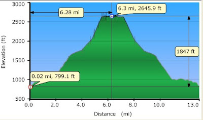
Elevaton profile log
Today I found the Southern trail head for the Dry Creek Trail. I wanted to go to the highpoint of the trail but the snow was too deep and the crossing of Le Bar creek looked dangerous. The log book was empty, not many people go up that way.
I started at the wild life gate and Le Bar horse camp and I biked until I hit snow at 1,800 feet. I mostly pushed my bike up the hill and did very little actual biking on the way up.
At 1,800 feet I ditched my bike and started hoofing it. I should have brought my gaiters, my feet got soaked. I also should have brought my snowshoes. Postholing is so exhausting!
Once I got back down to my bike I was able to coast most of the 4 miles back to my car. Still, I only went 13 miles including both biking hiking but I am totally wiped out from the postholing.
I met two forest service workers who passed me in their forest service truck, as they went up the road and again as they went down. The driver was an older man and he kept giving me warnings such as I was going to see snow and the weather was going to get bad. (He told me that the snow level was 3,800 feet!) The passenger, on the other hand, was a younger guy and he cheered me on. The goals of the forest service have changed over time!
The first mile of this trail is a closed logging road and I did not make it past the road and onto the trail. Even in the summer you need a very high clearance vehicle to get to the trail head due to extremely deep water bars across the road.
No comments:
Post a Comment