(I pitched a tarp so my family could stay dry if it rained. My family is asleep and am about to start my hike. After I left my dog woke up the entire campground barking for me to bring her along. What a bad dog!)

(lets go!)
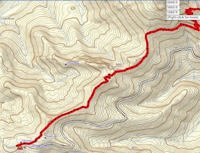
To Hurricane Ridge from “Heart ‘o the Hills” campground Via Lake Angeles, Switchback and Klahane ridge trails.
We camped at the rather pretentiously named “Heart ‘o the Hills” camp in Olympic National Park. While my family slept in I got up early and hit the trail at 6:45 am. The plan was for me to hike up to the Hurricane Ridge Visitor Center and meet my family there between 1-3 pm. My family was to drive up the hill and maybe even have a picnic lunch ready for me when I arrived.
The first few miles are in a rather boring forest but the forest is filled with saprophytic plants, so there might be good mushroom hunting on this trail, in the fall. On the way to the Lake the trail passes through and area where a massive blow down took place a few years back.

(windfall on the Lake Angeles Trail)

(saprophytes on the Lake Angeles Trail)
When I got to the turn off for Lake Angeles I threw down my pack and made a side-trip to see it. The last time I hiked this trail I did not see the lake and I wanted to see it this time. The lake was really pretty and above it I could see the cliffs that I would soon be walking up. Those cliffs looked like a forbidding challenge but I remembered that the trail was nice and very walkable.

(Lake Angeles and the cliffs above)
Still, I was glad to have my trekking poles with me when I reached the steepest part. I did fall down one time but luckily I caught myself with my left hand. I have not fallen on my right hand since my surgery and I’m dreading the first time it happens. I broke my right wrist on October 1st, and it still hurts some, I’m sure falling on it would be very painful.
When I got to the ridge and the same snow bank that I threw myself down on last time I took a break and brewed some vile tea. I knew that I would soon be hitting the switchback trail and all the crowds. It was almost perfect hiking weather this time though so I did not throw myself onto the snow. The other time I did this hike it was a hot day and I suffered for it. I threw myself down on a snow bank to cool off. This time when I reached the same snow bank I thought about putting my sweater on.

(Above Lake Angeles)

(cow parsnips and lupine)

(Klahane Ridge Trail)
Once you cross over the ridge the road is in plain sight and it no longer feels like a wilderness hike. But this time the switchback and ridge trails were not as crowded as I expected and I had fun trying to spot my family as I knew they would soon be driving up the road.

(The visitor center is up the road and around the corner)
After crossing the ridge the trail drops almost 1000 feet and then regains 200 feet only to drop another 200 feet only to regain it again. While I was losing that first 1000 feet I kept looking towards the visitor center and trying to gauge if I was higher or lower then the visitor center. I hoped I was higher then the visitor center because I did not want to have to regain any elevation. I bonked on the second to last regaining of elevation. I could have re-energized myself by eating lunch but I was trying to lose weight so I suffered onward without lunch.
The meadows on the ridge were lined with beautiful flowers. The flowers and the view looking down at Lake Angeles were the highlight of the trip. I could not see Port Angeles, it was obscured by a low cloud cover. I saw a goat way down on the Heather Park trail. I also saw two deer, one on the switchback trail and one near the visitor center.
I arrived at the Hurricane Ridge Visitors center at 2:20pm and that was just 5 minutes before my family arrived. I enjoyed the views and lunch at the Visitor center. Lunch was spam on bread with mustard and mayo. While my husband thinks spam in a wonderful treat, I only like spam when I am really hungry.
(Gourmet lunch at the visitor center)
This hike kicked my butt I feel pretty good today. I’m tired but I’m not sore. Going down steps is a bit awkward though. We took my car this time, so I did not get motion sick on the way back home.
(Hubby exhausted after the long drive up to the visitor center. This is happens when you smoke for too many years.)
(Our youngest drinking rainwater as it drips off the tarp after my hike was done)
According to my GPS, my average moving speed was 2 miles per hour. I was pushing myself to walk faster then normal on this hike. I am training for a possible climb up Mount Adams at the end of August.
10.8 miles
4,100 feet elevation gain
Total GPS elevation gain was 4,700 feet
106 shoe miles
Other times I have blogged this hike:
Friday, July 28, 2006

(Lake Angeles Trail)

(switchback trail)

(Klahane Ridge Trail)

(entire route with elevation profile)
No comments:
Post a Comment