


 |
| Smoker |


The Mildred Lakes Trail has always intrigued me. I was a hiking neophyte when I was first told about the horrors of this trail. Over the years I’ve read Robert L. Woods description of this hike several times and I have attempted to hike this trail once before.
My first attempt to hike to the lakes on Saturday, November 24, 2007 , ended early when it became clear that I was going to run out of daylight before I could make it to the lakes. A trail of orange ribbons not too far from the trail head had led me astray. I lost the trail several times whilst looking for more ribbons. If only I had used my eyes to look for the trail and ignored the ribbons, I might have made it.
 |
| Add caption |
On the morning of this new hike I woke up a bit tired. I used to always wake up excited on my hiking day. Maybe I’m getting bored with hiking? I got up and made a cup of tea and grabbed an extra pair of socks before I headed out the door. Then when I was half way between my door and my high clearance vehicle, I remembered that my lunch was still in the fridge so I went back and retrieved it. After that I ran back in the house to grab an extra pair of socks I had laid out on the couch the night before.
For this hike, I decided to leave my bad dog at home because I did not know how many other people would be on the trail and I don’t like to take her onto crowded trails.

On the road I stopped at Twin Totems to get gas and some breakfast. I was hoping to find a power bar in that tiny reservation gas station store. The store security guard started following me the minute he laid eyes on me. His eyes following me everywhere and caused me to abort my search for a power bar. I walked out with a pepperoni stick and the security guard smiled as me as I left. I nodded my head at him while giving him a look that could kill.
There is road construction on the 101 and in one spot I had to wait what seemed like far too long for a light to change. My car was the only one on the road, there was no need for the light to stay red for so damn long. I futilely honked my horn at the bright red stop light. I know my honking accomplished nothing as far as making the light change, but it made me feel better nonetheless.
I had no trouble driving to the trail head in spite of the two repaired road wash-outs. I reached the trail head fee area at about 8am. Mildred Lakes is an un-maintained way trail but the sign inside the outhouse said that I should not throw garbage down the outhouse hole because it is very difficult to remove and takes away money that could be used to maintain the trail.
To the Forest Service regulations say that a picnic table and a shit house constitutes enough trail maintenance for them to charge a fee. The forest service can only charge for parking at trail heads that have a shit house and a picnic table. The road and fancy bridges that lead to the trail head were built by the US taxpayers, so the timber companies could cut down the old growth forests. Now that all but the last 15% of the old grown here has been cut down, there is no need for the forest service to maintain the roads. It is the job of the forest service to plunk in an outhouse and a picnic table, if no almost no one can drive down the road to reach the trail head it makes no difference. As long as the trail head has an outhouse and a picnic table the you have to pay to park there.
Anyway…. There were about 5 other high clearance vehicles at the Mildred Lakes trail head. I started my hike at 8:15 am and I did not lose the trail at all on the way to huckleberry creek. I also did not see another hiker until I got to the creek. When I got to the creek I was able to easily find where the trail crossed thanks to several groups of backpackers who happened to be coming down as I was going up. They all crossed the creek on a log, but I chose to do a boulder hop to get over the stream. Several years ago I got hurt when I fell off a log and into a river in Montana. I've tried to avoid log crossings ever since then.
Shortly after crossing the creek I found the area where I lost the trail before. I saw the log that I had repeatedly crossed while looking for the trail; it turned out the log was the trail. Seeing that log brought back scary memories but I pushed onward.
Just after the log is the infamous ravine. You read about this ravine in most every trip report. But most trip reports don’t have pictures of the ravine. I imagined this ravine to be something far worse then it really was. In actuality this ravine is easier to traverse, then the second headwall, on the Putvin trail. Before I saw the ravine I had already decided to take and post several pictures of it. I’m doing this so other hikers will not have to imagine how bad it is. The imagination always makes things out to be much worse than they really are. Well at least that is how my imagination works.
After the ravine the trail started gaining elevation fast and I had to pause a few times to catch my breath, but before I knew it I had arrived at the first Mildred Lakes tarn. Yes! I am in top physical condition! The first little tarn is on the ridgeline ; the ridgeline is somewhat barren and rocky.
The second tarn that I saw blew my mind away with its beauty. My pictures will never be able to fully capture the way I felt when I saw that gorgeous little tarn. I reached into the tarn with both of my hands cupped and I drank deeply and directly of its mercury filled waters (I don’t believe the lies about China. I think the source of this mercury is the coal burning plant in Centralia.)
"At the second pool a little mountain hemlock, its trunk twisted like a pretzel, awaits the photographer at the water's edge" - Robert L. Woods (Olympic Mountain Trail Guide)
I have no fear of giardia and mosquito larva and as far as I know my filter does not remove mercury and pesticides, so there was no reason for me to filter the water. Yeah, I know that water was probably filled with all kinds of nasties. But I also know that the water coming out of my kitchen faucet is filled with nasties. Drinking directly from the waters of the mountains is a spiritual thing for me.
The rocky condition of the trail near the first few tarns made route finding difficult. In order to reach the first lake I ended up bushwhacking. I know you don’t have to bushwhack to the first lake, but I also know that many people before me have found themselves bushwhacking and bushwhacking to the first lake.
I followed my GPS topo map to get to the lake. I reasoned that if I just followed the outlet stream I could find the lake and find the trail around the lake. I needlessly crossed the outlet stream only to have to re-cross it when I saw the trail on the other side. With out my GPS, I might have gotten really lost here. But then again maybe not, I could after all hear the outlet steam and I could have used my ears to guide me to it. I also had a paper topo map in my pocket.
I felt relieved when after what seemed like an eternity, I found the lake and the trail. There were people camping at the lake and one of the campers yelled hello to me as I passed by their campsite. I had a short, but pleasant conversation with them. This conversation made me feel even better. I might have been a little creeped out if I had been all alone up there.
Shortly after my conversation I found a little beach area on the first lake and I stopped there to have a snack and take pictures. I thought about making this beach my turn around point. But I knew that after coming this far I had to see all the Mildred Lakes. I may never make it back up there again; it really could have been a case of now or never for the Lakes. Before I left the little beach I grabbed some water to pre-soak my lunch with. I intended to cook my lunch at the second lake and presoaking it would make it cook faster.
So I left the beach and saw an orange ribbon that was supposed to have marked the trail. Effing orange ribbon! The ribbon misled me. If only I had followed my eyes and my guts I would have found the trail and stayed on the trail. But instead I got very far off trail. Once again I had to rely on my GPS.
I knew that I was way off the trail this time, and I found it a bit frightening. I was climbing over logs and down ravines and I was alone. If I got hurt out there, chances were, it would have taken a very long time for anyone to find me.
I could not make up my mind if I should just use my GPS and make a bee-line for the largest lake, or if I should head down towards the outlet stream and try to find a trail there. The terrain was rugged and many large boulders and small rocky ridges made it too difficult for me to reach the outlet stream. I really was quite a ways off the trail. At one point I had to step onto a dead branch to climb over a big log that the branch was connected to. I knew the dead branch looked a bit sketchy and I figured I could get hurt if the branch broke under my weight. The branch did break, but it broke just as I was lifting my weight from it, so disaster was averted.
In the end I gave up trying to reach the outlet stream of the big lake and instead did two tenths of a mile of serious bushwhacking. I was well out of my comfort zone, but I tried to stay relaxed and I tried not to rush. I knew that if I went too fast my chances of getting hurt would go up. I was not happy about the predicament I found myself in and I was not having fun. Several times I thought about just going back to the first lake and calling it a day there. But I kept pushing on; I had come too far to turn back without seeing the main lake.
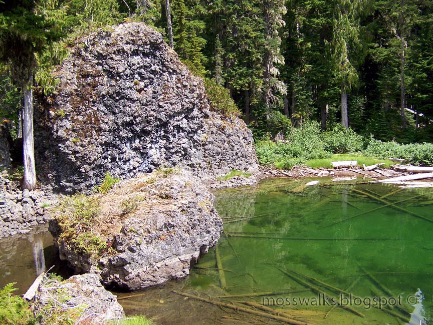
Eventually I stumbled over enough logs and slipped down into enough ravines and hyper extended my left knee enough times, to find a tarn that led to the big lake. By the time I found the tarn I was soaked with water from the bushes. Even my feet were soaking wet. That meant freedom! There is no need to try to keep wet feet dry, so when I saw the tarn I walked through it. Walking through the tarn was easier then trying to find the path around the tarn. This tarn was lined with pillow basalt and its shoreline looked very sketchy. After walking through the tarn I found the big lake on the other side.
I spent about 1.25 hours resting, cooking lunch and taking pictures at the lake. For this trip I packed my beer can pot and stove system. This cooking system only weighs 6 ounces, but it is slow. This system is great for simmering dehydrated meals but it’s too slow for boiling water for tea. I need to find a way to make this stove burn faster and if I succeed in that, I will also want to find a way to make the stove simmer. Maybe I should just pack two stoves. One stove for making a quick cup of tea and another stove for simmering. My stoves weigh less then an ounce so bringing two of them would not add much to my pack weight.
My camera decided to malfunction during my lunch break. The setting I use the most is the landscape setting but my camera refused to go into the landscape setting. Every time I switched the dial to landscape the camera went into its aperture priority mode. I have the aperture priority mode set to black and white so I took a few black and white shots while I was up there. Eventually after much fiddling around I got my camera to start working properly again.
Near my lunch spot on the isthmus between the second and the third lake I found a smoker that someone had built using mud and rocks. I also found a bunch of fish guts next to the smoker. The smoker was interesting to look at but thinking back on it I almost wish I had knocked it down.
Everyone at the lake seemed to be fishing. I was not fishing; I had my fill of fishing when I was a kid. When I was a child every family vacation we went on revolved around fishing. These days if I want fish I either buy it at the store or I ask my dad for it. If I want smoked fish I use my “Big Chief” smoker and alder chips.
Someday soon, I may confess to my father that I have no interest in fishing. But my father may take some consolation in the fact that the family fishing gene has simply skipped a generation and it was passed on my oldest daughter. Doubtless, my oldest daughter will detest hiking when she grows up. My father is not a hiker, but of course he has been to Mildred and Constance Lakes. My Father's, Father has also been to these lakes.
After my lunch break I made few false starts at finding the trail back to the first lake, but I did find it. By following the actual trail on the way back I got to see the middle lake and several more pretty little tarns. I did not have to do any more bushwhacking until I got to the trail head, but more on that later.
On my way back out I stopped at the high point of the hike and put on a dry pair of socks for the slog down. I moved very slowly and cautiously on the way down because I did not want to get hurt. Still, it only took me three hours to hike down while it took me 5 hours to hike up.
When I got back down to huckleberry creek I drank deeply from its E.coli infested waters and I took a break on its shore. But I did not rest as long as I had planned to because I could smell the scent human fecal matter wafting from a nearby riverside campground.
The Mildred Lakes Trail is literally lined with toilet paper blossoms. One could probably safely ignore all the effing orange ribbons and just follow the trail of toilet paper to the lake. I have never seen so much toilet paper on a trail in all my hiking life. This was also the first time I have ever seen human fecal material directly on a trail.
This is not a heavily traveled trail, so I have to blame the toilet paper blossoms on the type of people who use this trail. My dad writes a column in a fishing magazine and after I got home from this hike I asked him if he would write something about LNT methods and how to shit in the woods. Clearly some anglers don’t know how to shit in the woods. My dad informed me that he no longer writes that column and he does not believe that all toilet paper blossoms were left by anglers.
One pile of toilet paper covered shit was directly on the trail! Maybe I should not judge the anglers too harshly, the anglers probably all got the shits after eating the mercury filled fish up at the lakes.
On the way back to my high clearance vehicle, I noticed something that escaped my attention on the way up to the lakes. What I noticed was the largest yellow jacket nest I have ever seen and it was only three feet from the trail. I don't know how I avoided being stung the first time I walked past it. I took a 12 foot detour around the nest and I took some pictures of it from a distance, with my zoom lens.
From the creek, the trail down is relatively gentle and easy to follow. I don’t really understand how I lost the trail just one tenth of a mile from the trail head. But lost it I did. So once again I turned to my GPS to guide me in the right direction. But I probably could have gotten by with out the GPS, because sounds from the road below were reaching me in the woods. All I needed to do was listen for cars.
At the end of this hike I felt better and had more energy left over then I had at the end of my Gladys Divide hike. I think I felt more energetic because, although the hike to Mildred Lakes is rough, it is short. All of my bushwhacking, going off route, wandering around the lakes and getting lost must have added mileage to my Mildred Lakes hike, but my GPS recorded my hike as being under 10 miles round trip. My GPS was on battery saver mode for the first half the hike. Battery saver mode might have caused my GPS to register less way points. Another possibility is that the trail is really just 9 miles round trip and the trail length was over estimated by the forest service, due to it’s difficulty.
On my drive home I paused to take some pictures of an American car near Lena Creek camp.


After I left the camp I drove straight home with out taking any breaks. When I got out of my high clearance vehicle, I was surprised to find that I could barely walk. This hike took more out of me then I had realized.
(When I got home I was very pleasantly surprised to find that my husband had washed two loads of dishes and kept the house clean. He had also gone to the store and bought both laundry and dishwasher detergent.)
After my troubles getting out my high clearance vehicle, I knew I needed to move around some and do some more walking before I went to bed. Going on short walk the night after a long hike is said to help prevent stiffness in the morning. But a family issue prevented me from being able to walk around until after I had been home for several hours. Eventually I did make it out off the couch and out of the house and I took my dog for a 1 mile walk around town. But, when I first go up off the couch my back was really sore from sitting for too long.
The next morning (today) when I woke up I felt very stiff and sore. My entire body is sore! My arms, shoulders back and legs all hurt. So only now do I fully realize just how hard this hike was. Maybe all the hype about it is correct after all. In spite of all the hardships to be endured on this trail I would like to go back and do it again. The lakes and the tarns near the lakes are beautiful.
Miles 9.7
total ascent 2,400

GPS Trip Totals

Elevation Profile Log

Track Log of my convoluted route

Track Log of my convoluted route near the lakes
6 comments:
I have never heard of the Mildred Lakes hike, but I really enjoyed your write-up! So, anglers actually hike that crazy route just to fish in a lake?
I looked for the trail on redtrails.com and found it, but it's only 3.3 miles one-way. The trail also apparently goes right across one of the lakes! Obviously, they could use a trail with better GPS coordinates. The fs.fed.us site lists it as 4.4 miles one-way. But if there was a good trail that you could download to your GPS, you could use it the entire way to tell you which direction to go, correct? I know we have the same GPS units but I've never used mine in that way - generally just for the road and for 'tracking' my hikes.
I ask because I may want to attempt this trail someday. I don't think I could right now as I'm not in the best hiking shape :\ but perhaps by the end of the season or next years. I'm certainly not the best with trail-finding though, so a good trail log on my GPS would be helpful.
Thanks for posting this wonderful write-up!
Done!
I've backpacked to these lakes 7 times since 1986. Pepper's Smoker was made by Mike Pepper - a friend of mine who went up there with other's the weekend before you were there. I enjoyed the pics. As for the trail being littered with toilet paper, we have never seen that much evidence of it in the past 20 years. I did not make the trip this year, but apparently it is getting some heavy use. My wife and I attempted this hike earlier but quickly found out we were too out of shape for it this year. The amount of people that have signed into the register was surprising, especially considering the road washouts.
Nice report. Nice stove. Great pictures. Thanks.
DQ
Found your blog while reviewing Mildred lake posts. Great review! Sorry to hear about all of the nasty human evidence. I hiked this in July over a 4 day trip and the only human evidence we saw was a few boot prints. I guess it was early enough in the season that the we didn't see any trash or TP. The thought of the feces sickens me! I wish the road would have remained washed out.
Mildred Lakes was my first ever hike. I did it last summer with a sixty pound pack loaded with enough food and gear for a three day outing. My dog, Blue, accompanied me on this trip so naturally his food was in the pack also, along with all of my fishing equipment. I am a strictly catch and release fisherman, by the way, and let me tell you, the fishing at these lakes is phenomenal. So is the scenery. However, I can't say I came across one piece of TP. Or feces. Alas, I did stumble upon some bear and deer excrement, and I had some choice words for those naughty, uncivilized animals leaving waste on the trails. As a matter of fact I gathered them up for a little pow-wow around my illegal camp fire and, as I sat cross legged, scolded and berated them with liberal, human-hating terms such as "evolve" and "progress." Maybe now they will finally morph into bipedal creatures of some sort with enough intelligence to not shit in the woods. Come to think of it, I wish you had included a photo of the turd you found. Maybe you could add an addendum and include slightly more more detail such as size, shape, color, etc. I could possibly identify it as mine. Better still, when you decide to take your Subaru down that washed out road once more and brave the trail, if you could just simply retrieve that doo-doo and mail it to me I would appreciate it.
I found your write-up enjoyable, nay, hysterical! However you come across as having a strong sense of moral superiority in relation to others. Have you seen a doctor for this?
Subaru? Those are fighting words!
Post a Comment