|
| Foggy Smoggy view of Mt St Helens |
All of the pictures on this page will enlarge if you click on them.
 |
| Frozen chanterelles |
I got my little one off to school, listened to my husband bitch about stuff before he went to work, took my car to the body shop and then went for a mini hike.
I went up what I call Vincent Hill. I believe this hill has been misnamed. It would be a fun research project to determine how this hill that is nowhere near Grisdale got to be named Grisdale hill. The benchmark at the top says “Vincent” the creek that flows from it is called Vincent and the closest logging camp to this hill is was not Grisdale, it was Simpson camp #3.
This is not a pretty area, but sort of close to home and the view is really nice when there is no logging. There was a lot of logging today so I wore my headphones to drown out the logging noise and I had a nice hike. It took me 40 minutes to drive to the trail head; I timed it so I would know what time I had to be back down so I could be home in time to pick up my little one from school. I needed to head down at 2pm so I could be at the bottom by 3pm so I could be home by 3:45.
 |
| Lumber prices must be up |
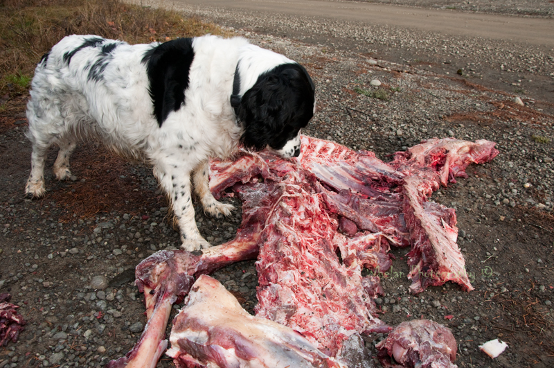
At the start of the road someone had left an elk carcass, gee thanks! Well Patches thought it was pretty neat anyway. The meat seemed really fresh so I let her have a go at playing “cave dog” and picking at the bones.
I’ve never seen elk in this area so I really wonder where the elk came from. Two poles had been set up for butchering it right at the spot where I like to roast marshmallows with my family. A lot of rope and a bungee cord were left on the poles. It seems to me that this animal was maybe butchered in a big hurry and the bones quickly dumped. But I don’t know, there was no sign of blood or guts under the poles, so maybe the poles had been used for something else. Maybe someone had set up a tarp there? Perhaps the bones were just dumped there after being de-meated somewhere else.
The bones were too big to be deer. All of the hooves had been cut off. I know that deer hooves are kept to sell to Native Americans to use in rattles, is the same done with elk hooves? The neck was there but there was no sign of the skull. I’m going to assume that someone took the skull home. Some meat was left behind and it looked to me like the knife got really dull in the process of butchering the animal. There will be pictures of this at the bottom, if it’s not the kind of thing you want to look at don’t scroll all the way down... I will post one more warning before the pictures...
I sat at the top for quite a while waiting for the clouds to part so I could take a perfect picture. But the clouds never quite parted and the air was very hazy down below. I was glad to be above the worst of the air pollution. The I-5 corridor was covered with thick brown smog. I could see the smokes coming from the Centralia coal plant and I think I saw the Shelton Simpson smoke and I could also see some sort of slash pile or garbage burn just off highway 101. I also saw a source of smoke that looked to be coming from the area of Hoodsport.
In spite of the haze I could see Mt Rainer, Mt Adams and Mt St Helens. It was too smoggy to see Mount Baker or anything else East of Seattle.
 |
| Full logging truck crosses the Skokomish on the High Steel Bridge |
I could see logging operations near Denney Ahl Hill but the hill its self was not being logged. I could also see a big orange crane between me and Lake Cushman. I could not tell what the crane was doing, logging I assume, but it could have been working on the road that goes down to Lake Cushman. You cannot see Lake Cushman from this spot because it is blocked by either Cushman Hill or Prospect Ridge.
The trees on the top have grown a lot since I first started hiking here and it is now very difficult to see Lake West from the summit of Vincent hill. I hope someone goes and tops those trees, it's not like they will ever get to be old growth on a Simpson / Green Diamond tree farm. In a couple more year there will be no view to the East.
The upper part of this road walk is pretty barren; there are not even an pretty lichens to look at until about half way down. Half way down there is a gravel pit that has a few bulls’ eye lichens. I found what will probably be my last chanterelles of the year. There were three of them and they were frozen solid, so I left them behind.
I still hope to go hiking again tomorrow. I still wish I knew what was wrong with my knee. My ankle brake worked great. It felt good to get out today in spite of going out to such an ugly and abused area. Maybe I can go someplace pretty tomorrow.
REI called, my bicycle is done, and perhaps I will go to Olympia and pick it up this afternoon. I have not released my lichens yet, but I think I will do it sometime in the next day or two; maybe I’ll do it during my next hike.
I removed my geocache from the hill today. I'm going to put it somewhere else.
It was not a good day for photography, the light was wrong and the sky was hazy.
4 miles
1,000 feet elevation gain
|
| Wrong lens for this pretty lichen |
 |
| Moss and lichens |
 |
| The Skok from Vincent Hill |
 |
| Used as a butchering pole? |
 |
| My geocache and other stuff |
If you don't want to see my dog eating a fresh elk carcass
stop here
.
.
.
.
.
.
.
.
.
.

 When I reached the summit I was afraid to sit because it looked like it could be a tick area. Then I found a tick on my leg. Then I looked at Patches and found she was crawling with ticks!