On my way to the trail head I noticed that potlatch was flooded from a high tide with evidence that the water reached the sidewalk next to the bathrooms. I stopped and took a few pictures.


The tide washed debris onto the sidewalk.

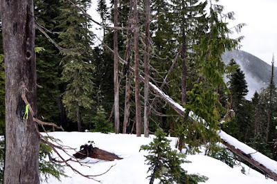
With the snow levels being so high and a recent trip report of a successful hike up Mount Rose, I thought I would be able to do this. The trail was free of snow until 3,400 feet! I thought that for sure I would be able to summit. But on the ridge the snow was very deep and it felt risky. I was solo and I worried about falling into a tree well.
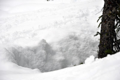
When I was on the ridge I probed the snow with my trekking poles before each step, so I would not fall into a tree well. But at one point my left foot plunged in and I sunk to my mid-thigh while my right foot was sunk in at knee level. And I could not get up because my hands sunk into the snow when I tried to use them to pull myself up. I knew what to do though, I took off my pack and laid it on the snow and used it to push up against. Then I turned around. I made it to about 4,100 feet so I was just 300 feet shy of the summit elevation wise, but it was too risky for me to go on.
Still I enjoyed my hike and I felt very relaxed and happy on the way down.
This hike was a good test of my new boots with my crampons. My crampons did not fall off my boots at all because they were made to hold crampons. My feet also stayed dry.
This is the first time I have hiked in these boots without getting blisters. I avoided blistering by wearing a really thin slippery liner sock under my regular socks.
The crampons were really helpful on the snow but they were not absolutely needed for this hike. Snowshoes might have been better but, I knew that if I had fallen upside down into a tree well with snowshoes on I really would have been in trouble, so I did not miss having them.
I had my lunch back down in the forest and instead of tea I warmed up some "instant soy milk drink". The drink was good and it gave me some extra calories.
7 miles
3,100 feet elevation gain
Average moving speed 2.7 MPH
Car to car 5 1/2 hours
Miles on my boots?

Track log, todays track is yellow, the gray track shows where the trail is.


The trail

Mossy rock

First set of benches

Arrow

First patchy snow at 3,400

Do you really expect me to eat this? Look at all the spots.

Digging my heels in for the descent

The ridge trail on the way back

On the ridge mount Ellinor in the back ground.

Open tree well, so no danger here, but warns of potential for danger.

Hemlock quads. When I lost the trail on the way up I knew I was in the right place when I recognized these trees.

A hole to fall into, view is looking straight down.

Time to turn around but first I have to get out of this hole.


This cut logged reassured me that I was on the trail
The trail on the ridge.
2 comments:
Thanks for the great pics! I was wondering where the snow started for Mt. Townsend and now I know, prob around 3400', about the start of the upper trail head. Guess I'll go to Lena instead. Maybe I can make the Valley of the Silent Men.
Your pics the other day of the road up the Dosi made me think I need to think about getting a low end trail bicycle. Seems there are a lot of closed roads. Your pics made me think those would be GREAT places to cruise down. A lot less of crowds. Do you have any advice on getting started biking/hiking down roads like that? What shoes? Would a low end bike be ok?
-Scot
Hi Scot,
Thanks for the compliments on my pictures.
I'm not the best one to ask about biking because I am fairly new at it. I'm still more comfortable withmy feet on the ground hiking.
There are a lot of spots on the road to Dose where you would have to get off and walk across landslides and creeks and stuff. But I do see a few cylists out there. I think most cyclists go to the south end of the Capital Forest.
Post a Comment